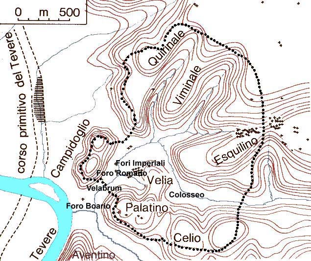
ALRItkwRom101BasicTopo.html
Basic Rome City Topography

Traditionally Rome is said to be founded on seven hills, but the history and the topography of Rome is a bit more complicated than that.

Rome's Seven Hills: The hills are not really isolated hills.  Rather they are a series of ridges eroded from a plain above the floodplain of the Tiber river.  Erosion has separated the ends of some of the ridges into freestanding heights.  It's easy to understand if you look at the contour map below.  Note also that the slopes of the hills and ridges were much steeper  in ancient times and the valley bottoms were much closer to the level of the Tiber than they are today -- both natural action and human intervention have smoothed the contours and softened the edges.

Palatine Hill (Palatium = Palatino) The central hill and where the city of Rome was founded by Romulus according to legend. The myth is corroborated by archaeological finds from the iron age (10th century through 8th century BC ) of huts and primitive defensive walls around the hill. The Palatine remained the center of power throughout the history of Rome, first as the residential area of choice of the most wealthy patricians, later as the residence of the emperors. Significantly, the word palace stems from the name palatinus.  The Velia, a northward extension of the Palatine, was the site of the first Roman temples in the Forum Romanum.

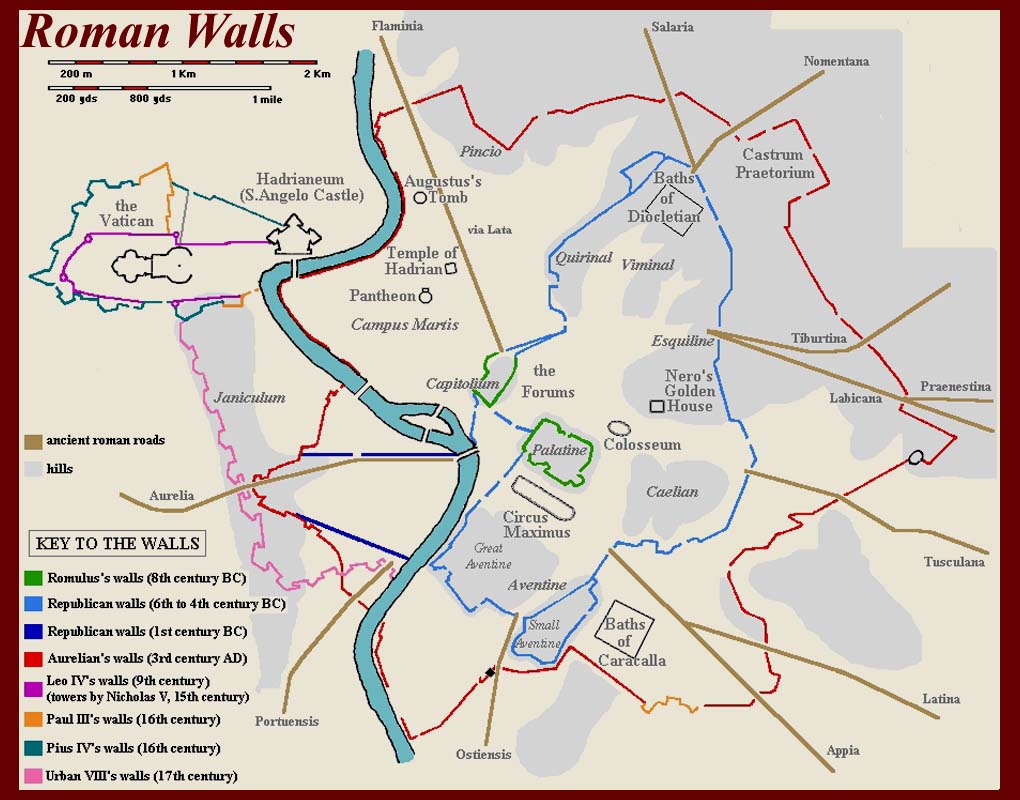
Capitoline Hill (Capitolium = Campidoglio) This hill was very steep and soon became the fortified stronghold of Rome. When the Gauls sacked Rome in 390 BCE, only the Capitol held out. Later it became the religious center, due to the presence of the Temple of Jupiter Capitolinus Best and Greatest. The Capitoline Hill has two summits, the Capitoline proper to the south and the Arx to the north, with the Asylum on the ridge between them. The Arx is now occupied by the church of Santa Maria in Aracoeli and the modern Vittoriano. The Asylum is now the Piazza di Campidoglio.

Quirinal Hill (Quirinalis = Quirinale) The Quirinal is the northernmost of four spurs of the high ground east of the Tiber that lay within the limits of Republican Rome. It rose above the Campus Martius and was attached to the Capitoline Hill by a low ridge. The hill is named after the ancient god Quirinus, a member of the earliest Capitoline Triad.

Viminal Hill (Viminalis = Viminale) The Viminal is a smaller ridge between the Quirinal Hill and the Esquiline Hill.

Esquiline Hill (Esquiliae = Esquilino) The Esquiline is one of the largest hills, between the Viminal Hill and the Caelian Hill. Various parts of the Esquiline Hill have separate names. The Cispian peak (Cispius) is a small ridge just north of the Esquiline and the western side is called Fagutal (Fagutalis) and the southern side Oppian (Oppius). The Esquiline Hill was connected to the Palatine Hill via a ridge called the Velia, which was all but leveled in late antiquity.

Caelian Hill (Caelius = Celio) The Caelian Hill is the southernmost of the four large spurs. It stretches from the area of San Giovanni in Laterano to the Colosseum. It had two high points, referred to as the Larger Caelian (Caelius maior), to the west, and the Smaller Caelian (Caelius minor), to the north.

Aventine Hill (Aventinus = Aventino) The Aventine Hill is to the south and the last of the seven hill. It is detached from the other hills, and separated from the Palatine Hill by the valley of the Circus Maximus. The Aventine was traditionally the territory of the plebeians, who had their main temples and sanctuaries there.  It is shown at the very bottom of the map, south of the Capitoline and outside the dotted line of the Pomerium.

 
The Seven Hills of Rome Mnemonic: In Victorian times, every English schoolboy could recite the names of Rome's traditional Seven hills.  (Girls weren't expected to know such things.)  So how did they remember?  They were taught a simple mnemonic to remember the first letter of the name of each hill. 

Here it is, so that we can remember them too: 
Can Queen Victoria eat cold apple pie? 

The first letters correspond to: 
Capitoline, Quirinal, Viminal, Esquiline, Caelian, Aventine, and Palatine, 

Other "unofficial" hills apparently need not be remembered. 

Outside the ancient city limits were other hills, that would later be incorporated into the city as it grew.

Pincian Hill (Pincius) The Pincian Hill is to the north of the Quirinal Hill, overlooking the Campus Martius. The Pincian was mostly gardens, and was referred to as the Collis Hortolorum, the hill of gardens. There is still a park today with a beautiful view over the Piazza del Popolo.

The Aventine (Aventinus) is south of the Palatine and was one of the traditional seven hills.  It is not labeled, but you can just see the beginning of its rise at the bottom edge of the map above.  It is the traditional site of the rival settlement set up by Remus while Romulus was leading the settlement of the Palatine.  It was always outside the Pomerium, and therefore was, along with the areas on the western bank of the Tiber, where foreigners were allowed to live.  As noted above, it also was a traditional Plebian stronghold.

 
Trans Tiberium = across the Tiber = Trastevere.  Trastevere is the modern Italian name for the part of Rome on the western bank of the Tiber river, and from ancient times it was an area outside the Pomerium where foreigners were allowed to live.  In the first century BC, Trans Tiberium was where the Jewish international traders settled, and it later became the center of early Christian activity. 
Across the Tiber were other hills:

Janiculum (Janiculum = Janiculo) The Janiculum is a tall, elongated ridge, oriented mostly north-south. In the earliest time the Janiculum was the northern border of Rome, with Etruscan territory on the other side. In times of war a flag would be planted on the hill to signal to the enemy that Rome was ready. The name is after Janus, the two-faced god.

Vatican Hill (Vaticanus = Vaticano) The Vatican Hill is parallel to the Janiculum, further north. It overlooked a flat area to the north, the Vatican Fields, where the Basilica of Saint Peter, the Vatican State and the Castel Sant'Angelo now are.  St. Peter's Church and the Vatican are in their present location because the supposed site f the execution of St. Peter was at the base of an obelish in the center of the spina of the Circus of Nero built in the Vatican fields.  Twentieth Century excavations found a monumental tomb off the north side of the Neronian circus that has been identified as the tomb of St. Peter.  The Tomb is directly below the Papal altar of St. Peters Church.  The obelisk was moved to its present location in the center of Piazza S. Pietro when the current church (still called New St. Peters) was built during the Renaissance.  Castel Sant'Angelo was oricinally the tomb of Hadrian.


Where there are hills, there must be valleys:

The Forum Romanum is in the valley between the Palatine, the Capitoline and the Esquiline hills.  The Republican Forum was built in the valley bottom and the Imperial Forums were built a little to the north on and into the slopes of the Quirinale Hill.

The Velabrum is the area between the Palatine and the Capitoline hills.  In ancient times there was a slight rise here which made the area now covered by the Republican Forum ( = Foro Romano) an unusable swamp.  To drain the swamp a larve sewer tunnel, the cloaca maxima, was driven through the Velabrum down to the Tiber.  This project was realized during the late monarchical period, ca. 600 BC.

Between the Aventine and the Palatine is a long straight creek-bed depression where the Circus Maximus was later built.

Where the Velabrum and the Circus Maximus meets, between the Capitoline, Palatine and Aventine hills were the first Roman harbor and the marketplace of Rome, the Forum Boarium (Cattle Forum) and the Forum Holitarium (Vegetable Forum).

East of the Velia, between the Esquiline, Palatine, and Caelian hills, is the area of the Colosseum (=Colosseo) where there was a small lake before the construction of the Colosseum. Nero incorporated the lake into his Domus Aurea complex (as a feature in the huge central courtyard).  Vespasian, who folowed Nero after the "year of the four emperors" (68-69 AD) drained the lake by tunneling a sewer through the Velia to join up with the cloaca maxima in the Forum Romanum.  After the water drained away, construction on the Colosseum began.

The Field of Mars (Campus Martius) was a large plain just north of the archaic city, surrounded by the Capitoline, Esquiline and Pincian hills to the east and by the Tiber on the other sides. The army would convene in the Campus Martius before war and military commanders were elected there, as no military activities were allowed with the sacred city limit, the Pomerium.  It was also the sit of encamplents of returning victorious armies who were waiting for the formal "Triumph" ceremonies to their General.  Dozens of temples were eventually built in the Campus Martius by victorious Generals as thank-offerings to their favorite gods and goddesses.  Remains of four of these temples have been exposed in a small archeological park in the modern Piazza Argentina.

All of these areas were subject to seasonal flooding, and some archeologists say that the reason that Roman Temples were set on such high podiums was to keep them above the high water mark.  The Temple of Portunus, still on its high podium in the Forum Boarium, was completely surrounded by  water when the Tiber River rose above its banks during seasonal floods which continued to occur until the flood-control dikes were built along the River in the 1880s.
 

Development of the city (in a few lines)

It appears that the first settlement in the area was actually on the island (Tiber Island = Insula Tiberina = Isola Tiberina) in the Tiber River, which has been inhabited continuously since the Bronze Age (14th Century BC).  Very early in the Roman Monarchical period, the Island became a medical quarantine area and, until today, the main activity on the Island is a hospital.

There are remains of a thatched-hut settlement (often identified as the Roma Quadrata of Romulus) on the Palatine Hill and of burials at the western end of the Forum Romanum that date from the middle of the 8th century BC -- corresponding to the traditional date of the foundation of Rome by Romulus in 753 BC.  The Palatine soon became the habitation of rich patrician families and eventually the site of the imperial palaces.

At about the same time as the Romulan settlement on the Palatine, there were Latins living on the Aventine and Sabines living on the Quirinale.  Remains of an archaic oak-grove sacred area also have been excavated on the Quirinale.  (The name of the hill is thought to have ben derived from the Latin word "quercus", which means "oak tree", or perhaps the word for oak came from the name of the hill -- relationship established, but precednce unknown.)

There were two sacred areas on the two peaks of the Capitoline Hill ( = Campidoglio) from the earliest Roman times.  These were the site of the Temple of Jupiter Optimus Maximus on the southern peak and the site of the open-air Arx (where the "augurs" studied bird movements to try to determine the will of the gods) on the northern peak.  Eventually a temple of Juno Moneta ( = "the Protector") was build on the Arx.  The Juno Moneta temple was used as a mint for Roman money, and the modern words "money", "monetary", "mint", etc. are all derived from the Latin word "moneta" in the name of the Juno Temple.

The saddle between the two peaks of the Capitoline Hill was called the asylum (from Greek "asulon" = "sanctuary").  In the Monarchical Period and early Republican Rome, prospective new settlers -- often outlaws from surrounding tribes, who were actively recruited -- were allowed to settle provisionally until the learned and accepted the rules of Roman civilization.  After a trial period they were allowed out of the asylum and ito other parts of Rome.

The areas between the Quirinale Hill and the Viminale and between the Viminale and the Esquiline Hill (ie., north of the Forums) became the "Saburra"  (perhaps from "sub urba" = "below the city") where most of Rome's plebian population initially settled.  It quickly became an erea of low repute.

City walls were first built around the Palatine and gradually expanded as needed.  See the map below.  For a detailed description of Rome's walls go to http://www.geocities.com/Paris/Arc/5319/walls.htm.

mmdtkw -- verified September 2008